Mapping
Description
This section is from the book "Camping And Woodcraft", by Horace Kephart. Also available from Amazon: Camping and Woodcraft.
Mapping
Observe that a mere route sketch is only intended to show the way from one point to another, and tell the user where he is at any stage of the journey. Hence it need not be mathematically accurate, and hence it can be made swiftly, with crude instruments. Mapping proper is much slower work. Still, a very useful and practical map of a region several miles square can be made in a few days by one man, combining his route sketches, provided he takes a little more pains in locating a few prominent landmarks as "controls".
In the example already given the country was so heavily timbered that there were few outlooks from which mountain tops or other features could be observed from different points on the journey. If there had been such, I would have noted their bear* ings from different positions, and thus would have had a series of positive checks or controls by which to regulate my sketches. How this is done is shown in Fig. 16, which is reproduced from an article in Outing, by C. H. Morrill. In this case 34x7 notebook was used, the left-hand page being ruled for notes on compass bearings, distances (a pedometer was carried), time, etc., while the sketch was drawn on the right-hand page. Notice the compass bearings of mountains, brooks and pond.
If a similar trip had been made a few miles away, and bearings taken on objects visible on the first route, the two sketches could be combined into a map, as in Fig. 15. Where there were discrepancies they could be humored in by "splitting the difference," and the finished work would be true enough for practical purposes.
If one has a reliable map of the region he is in, but on too small a scale to show the details that he wants to record, he can use some of the major features on the map as controls, and thus make his sketch map pretty accurate.
A method of making more accurate sketch maps with an improvised plane table, or with a cavalry sketching case carried on the left wrist, is given in a handy little pocket manual of Military Map Read-ing; Field, Outpost and Road Sketching, by Major Wm. D. Beach, U. S. A. (Hudson Publishing Co., Kansas City, Mo.).
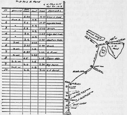
Fig. 16. Route sketch by C. H. Morrill.
Continue to: