Aerial Cameras, Aerial Films, And Film Processing
Description
This section is from the book "Aerial Cameras, Aerial Films, And Film Processing", by Richard W. Underwood.
Aerial Cameras, Aerial Films, And Film Processing
For over a hundred years man has been capable of leaving the surface of the Earth accompanied by the camera. A century ago, both his aerial vehicle and aerial camera were quite rudimentary. Figure 1 is a reproduction of a photograph made in 1860 by C. W. Black aboard a tethered balloon some 300 meters above Boston, Massachusetts. It is the first recorded aerial photograph taken in the United States and certainly one of the very first ever taken. The "wet plate" was immediately processed by Mr. Black and his eager young assistants. One assistant, Oliver Wendell Holmes, recorded in his diary, "This is indeed a most remarkable thing." Although Holmes did not achieve greatness in the photographic profession, he did become a most distinguished man of letters and a long-time Justice of the Supreme Court of the United States.
It truly was a most remarkable thing. Few modern engineering works involving the utilization of the surface of the Earth have been accomplished without the use of aerial photography.
Aerial photographic technology was quite dormant until the powered aircraft became a fairly efficient platform. Early aerial cameras were heavy and generally unreliable. Many used photographic emulsions on glass plates. Flexible films of nitrate base were highly flammable and dangerous in aircraft. Optical-mechanical devices used in mapping projects were rudimentary and far from precise.
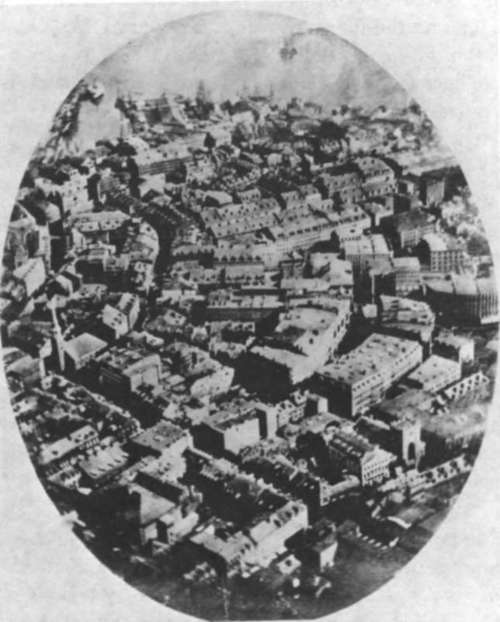
Figure 1. Aerial photo of Boston, Massachusetts, taken in 1860 (courtesy GAF Corp.).
But, as the needs for accurate information grew, greatly improved cameras, films, processing equipment, and plotting devices were developed.
In the past few years, it has become apparent that the aerial photograph is an essential tool working in concert with a multitude of remote sensors designed to secure information in other portions of the electromagnetic spectrum. The very limited portion of the spectrum available to photography practically coincides with the recording ability of the human eye. The unique combination of Earth-orbiting spacecraft or high-efficiency aircraft, photography, and other remote sensors has started a true renaissance in the ability to conduct detailed, comprehensive, and highly productive Earth resources surveys.
Actually, any camera used from an aircraft is capable of recording valuable information. It is a grave mistake, however, to attempt to secure information beyond the capabilities of any part of the system. It is absolutely mandatory that we discuss the system concept (that is, the aerial camera, the film, and the film processing techniques). Any violation of the system concept negates your ability to conduct accurate studies. This point cannot be overemphasized.
Continue to: